Buck Taylor - Pararaha Valley - Muir - Walker Ridge - Odlin Timber Track Loop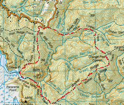
Head to carpark on Lone Kauri Rd. Start out on Buck Taylor Track straight ahead. The beginning of this track is through an eerie kind of tunnel of manuka/kunuka trees (still haven’t sussed out the difference) and there is a slight incline. Afterwards the canopy dissipates and it becomes a country walk on a hillside overlooking paddocks & bush amongst some tall daisies. The incline becomes slightly steeper at this stage. Before you know it, you are back in the bush again & the track heads downwards. After about 15 minutes or so from starting out is the junction for the Zion Ridge track on the right. We continue on the Buck Taylor track straight ahead and downwards (although the gradient lessens a tad). As the track gets further down the canopy overhead thickens & and the downwards gradient gets steeper. The track has more roots & rocks to scramble down & the trees get noticeably larger and with the denser canopy the light is also a tad dimmer (& there’s some cool moss about too). As the track continues there are a couple of viewpoints where there are gaps in the trees & you can look out below to the stream & wetlands of Pararaha Bay. After about 45 minutes from starting out you reach the end of the track at the junction of Zion Hill Track on the right and the Pararaha Valley Track veering slightly left. We head down the Pararaha Valley Track. The track continues downwards and the bush thins out giving way to manukas & flax with rock face on the left & a few cool looking thistles. The track then is a boardwalk over the marsh and with reeds & grassy stuff on the right. After the board walk the track is sand & mud & looks recently widened for quad bike access. We also enjoy looking up at the rocky cliffs either side of the valley, especially the rock known as “Baldy” which from some angles looks like a gorilla & other angles looks like Jabba the Hutt. After about 15 minutes or so from starting this track we cross the Pararaha Stream which happens to be just over boot level , so we all get wet feet. We are most pleased that it is heaps lower than when we last crossed it in mid winter, when it happened to be waist deep. It just goes to show how much the level varies. This crossing was in Spring , so the level probably drops even further in Summer. On the other side of the stream is the a grassy clearing with the Les Ward Hut on the right & the camp site next to the stream on the left. We decide to head along next to the stream & search out a nice spot for a cuppa & some Golden Crunch Cookies. After refuelling we got back on to the track & head for the Muir Track. The junction for this is after the hut on the right, heading up the grassy clearing uphill and back into the bush. The Muir track zig zigs quite steeply upwards and at one point it goes up the rock which has rope bolted into it for ease & safety. From that point it levels off with rock face on the right & a tranquil stream on the left. There are plenty of nikaus here and its nice & lush & green. After a minute or so the track continues uphill again with wider zig zags and then straightens off. We reach the end of this track approx 45 minutes later where it meets up with the junction of the Gibbons track on the right & the Walker Ridge Track straight ahead. We head straight on and this track starts out pretty flat & with the odd patch of mud. We come across some pretty big pine trees with cool knobbly roots (even though they’re not native, they’re still pretty cool all the same). After those, the track closes in a bit & there’s big grassy stuff on either side & then it descends at a reasonable gradient before heading upwards again. This down & up bit is also exposed and has some pretty good views of the bush & the sea behind you. After the ascent, the track flattens off again and also there’s a bit of mud here & there for squelching. As you get further along, the bush becomes more dense. After an hour from starting this track we reach the junction of Orange peel corner. To the right the Walker Ridge track continues towards Karamautura Forks & straight ahead, the Odlins Timber Track begins. We head straight on & the Odlins Timber Track which heads downwards pretty much straight away on orangey brown clay & is pretty slippery at times. Every now & then between the trees you can catch glimpses of the Pararaha Valley on your left. After about 20 minutes the track levels off and we come across the Cowan Stream & the campsite (flat surface with a longdrop). As there are people already at the campsite we realise our lunch stop is taken. That happened to be a good thing as we then discovered a track alongside the stream (on the other side) which we follow until we find a great spot on the rocks for our lunch of Thai Red Curry Sarnies & a nice cuppa. After lunch we explore this track further & find a small waterfall. We a mental note of this track to return another time after consulting our maps & planning another loop. We head back to the Odlins Timber Track which goes up a bit & back down again and we reach the Pararaha stream about 20 minutes or so later. After this crossing the track is steadily upwards & mostly stairs (not the prissy Cascade stairs but more looser stairs to hold the earth ) for the roughly half an hour until we reach the carpark about just over an hour from when we started this track. Total loop time is about 4 ½ hours. |
Level of DifficultyModerate
Total Loop Time4.5 hours (Spring 2011)
|
|
