Auckland City - Upper Kauri - Robinson Ridge - Fence Line - Waitakere Dam - Anderson Track Loop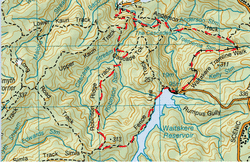
Head to the End of Falls Rd (past the golf course).
Start off on the city slickers paved walking track, Auckland City Walk down the hill and across the bridge for about 10 minutes until you see the junction for the Upper Kauri Track on your right. This is a gravel pathway that has a steady incline and a few steps with quite a few mature kauris and a few teenage ones on the way. These manicured gravel tracks are not our thing at all (give us mud any day), but the bush is still spectacular on this track you can hear the Cascade Falls quite clearly. Close to the top you come across a junction to your left of the Cascade Loop track. This heads down on platforms and stairs. Again were prefer the bush left alone, but understand that it’s for protection of the mighty kauris and their roots as this region gets quite a bit of foot traffic. The Kauri here are magnificent and the moss is just out of this world, there’s definitely quite a cool feeling being at the bottom of this valley (despite the man made aspect of the walkway). After a while (and a few more artificial steps) you come across another junction of the Robinsons Ridge track to your right. This track is much more natural so we can begin our tramp proper. The bits before were great to see, but we really feel at home walking on Mother Earth – and the mud. This track heads up, it does go down slightly to meet a pretty little stream which we contemplate having tea and biccies, but this place is totally shaded and cool air was coming off the stream (it was mid-winter for us), so we carried on looking for a wee sunbeam. Remembering the “down - up” rule, after this stream we continue up along the ridge which is straight and we are walking on red clay. After about 1 ½ hrs we decide to stop mid track for tea and biccies as we see some sun beaming through. We then continue on the steady incline and we are starting to get a few views from the ridge now. At the top we pass by the old fenceline track junction on the left. Seems silly to us that they blocked it off (as it was steep apparently), some trampers like steep tracks. Why didn’t DoC just leave the old one to give everyone options? Anyway, a few minutes later on the left is the junction for the new fenceline track. This is a gradual man-made gravel path with a sloping downward path which runs along side of the Waitakere Reservoir which looks beauty when calm, reflecting the surrounding scenery. It’s not long before you come out into the clearing on the left you pass the entrance to the old fenceline track (again causing grumbles to why they closed it off and not have two different tracks) and you walk along a big grassy bank as you head towards the dam. We then head right across the top of the dam, it’s quite amazing to think of the massive amount of concrete went into this thing. There is quite a height to this with great view looking down the valley. Once across the dam we pass the stairs going down the dam (we did have a wee detour for a bit of a look about), then past the loos to the left, then up the tar sealed road for about 10 metres. We head down some stairs also on the left (not the ones down the side of the dam) on to the tram lines (you may have guessed this is the Tramline track). We head along this track (discussing scenes from “Stand by me”) on the side of the cliff with great views of the valley below and you even get to walk under a small waterfall where there is a viaduct to carry this water over head of the tramline. It wasn’t long before we also discovered that this line was still in use, which has a small train to carry happy families who fancy a ride to the dam. There is plenty of room to stand aside so you don’t have to get squashed or clamber up the side of the cliff . There is also a tunnel about 50 metres or so that you walk through. After passing a derelict tram/train station there is a junction to where straight ahead is another tunnel and the Andersons Track to the left. We go left. The start of this track is rocky with lots of lovely moss on one side and views of the valley, falls and dam on the other. It’s all pretty flat-ish for about half an hour, then you pass the junction (of the Peripatus track to the right) and we continue to go straight, this now descends (past numerous young thin kauris) and before you know it you’re back in man made track territory with steps again. At the bottom we encounter a gravel pathway and soon enough a junction to the Auckland City Walk which heads both left and right (right heads towards the car park) we head left on the Auckland City Walk heading toward the Cascade Falls and then left again at the sign to the Cascade Falls (just follow your ears). This part is beautiful, it’s got huge rocks, plenty of moss and is in a valley with the stream to one side. You get to end of the track and while you can still hear the falls you just can’t see them (as they’re tucked away behind rocks and the cliff side). If you clamber over these rocks and perch precariously you can catch a wee glimpse of the falls. It seems really strange that there’s man made steps, bridges and manicured pathways all around these falls, yet there is nothing built for the average person (that these easy access pathways are designed for) to be able to view them. A small platform would surely suffice? After the sighting of these falls we waded across the stream and sat in a sunbeam for lunch and to soak in our picturesque surroundings. Afterwards we headed back down the Cascade track for a few minutes (and alongside the stream), pass by the track on our left (Upper Kauri) we initially headed up and back along the bridge to complete our loop. |
Level of DifficultyEasy
Total Loop Time4.5 hours (Winter 2011)
|
|
