Chateau Mosquito - Sisam - Long Rd - Ridge Rd - RGB Loop Track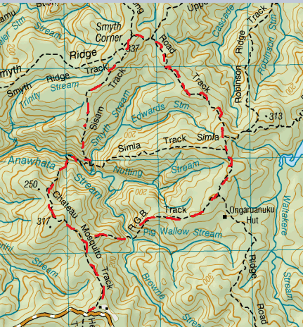
Track starts from Anawhata Rd. Chateau Mosquito starts off on a fairly wide flat track, that slowly starts to slope upwards and the ground becomes fairly hard, orange clay (and at times slippery) for about 30 mins.
Along this bit you’ll pass the junction for the RGB on the right. You may also find you may have an audience of curious Tomtits or Faintails investigating. Finally the track closes in and the bush becomes dense, lush and green with plenty of nice moss amongst plenty of other cool bush stuff. As well as your footing, watch your head as there is plenty of interesting flora and fauna plus fallen trees to go through and duck under. The track then descends quite steeply toward the Anawhata stream. To get to the stream takes just over an hour . On crossing this stream we found it made for a very picturesque place for a cuppa tea (and golden crunch biccies) looking across at a wonderful great big moss-covered rock and the trickle of water on the stream rocks. The track takes you alongside the stream for a few minutes, then down to the stream again to get really alongside it, walking precariously along a slippery rock (just look out for the bright markers that indicate where to go) before ascending up the valley again (back to the rule if there’s a stream there’ll be a “down” then an “up”). After this steep scramble you come across the end of the track (approx 1 ½ hrs) and a junction between the Sisam Track and Simla Track. On this occasion we connected on to the Sisam. This was a ridge with a slight incline and plenty of mud for squelching in (bear in mind this was mid-winter). There’re plenty of cool trees and moss on this one too (but not as cool as the Chateau Mosquito). This track comes to another junction (after about ¾ hr), Smyths Corner. This junction is where Smyth Ridge Track and Upper Kauri Track meet up. We head right for about 10 minutes and turn right onto the Long Rd Track (the signage is a tad obscure here, but common sense prevails). The Long Road Track is pretty wide and straight with lots of orange mud and great big puddles for plenty of squelching, splishing and splashing – this mud does try to suck off your shoes adding to the fun. After about half an hour we come across the RGB track (after passing the junction for the Simla Track). At this stage we were getting pretty hungry and hadn't found a place that stood out as a lunch spot so we sat by the side of the RGB for lunch (where there are a few trees...this is a nice spot for a bite and a cuppa). The RGB starts off pretty easy and flat, then gets pretty damn steep, there’re plenty of roots to hold on to, but sometimes you need to make some pretty big steps (climbing down can often put a lot more excursion on ones legs than climbing up – you’ll see what we mean when you do it). At the bottom is where the Pigs Wallow Stream meets the Browne Stream with little waterfall/rapidy things – now this would have made a great lunch spot. There’s a wee pool here for those who might be considering to cool off. As it was mid winter, we admired its beauty and moved on...remembering the “down/ up “ rule of streams we knew we had another climb ahead. This was another steep climb, you could definitely feel the burn on your thighs especially after making some pretty big steps in places. Once you have the reward of getting to the top of the valley the track continues for a couple of minutes until you come out at the Chateau Mosquito again (about an hour later). We turned left and headed for the car finishing about 4½ hrs later. |
Level of DifficultyMedium
Total Loop Time4.5 hours (Winter 2011)
|
|
