Dickey Flat / Mangakino Track Loop (Kaimai Ranges)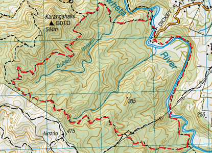
Head to carpark at the end of Dickey Flat Road.
This carpark is also for the Dickey Flat campsite which is in quite a peaceful setting where you can camp amongst the trees right next to the river. We start off walking through the Dickey Flat campsite and head towards the Waitawheta River where we veer right. After a minute or so we see the bridge ahead which we cross. After the bridge crossing we head right and follow the track along the river. Close to 10 minutes later we reach a junction. To the left is the Dubbo 96 Track heading up into the bush and to the right is the Crown Track heading across the Waitawheta River. We headed left. We leave the bubbling sounds of the river in exchange for the birdsong of the bush on a track which gently slopes upwards. After a while the track then heads downwards to the tranquil stream crossing of the Dubbo Stream, then of course it’s back up again as the track means to go on. Close to an hour from starting out, the Dubbo 96 Track ends at a T junction where the County Road Track leads both left and right. We head left. This track is wide enough for a vehicle and slopes very gradually upwards. It takes a bit of time to get some height, but after a while there are a few view points where there are breaks in the bush. We stop track side by one of these gaps for a morning tea & to take in some of the views of the surrounding hills & countryside. After about an hour on this winding, easy gradient we reach a cross roads intersection. Straight ahead is a distinct track and signposted as Unused Road (not showing on Topo Map), on the left is the Mangakino Track and to the right the County Road Track continues (signage showing To Karangahake Summit). We head left. The Mangakino Track is a narrow and winding tramping track. There are plenty of trees to climb over, branches & supple jack to duck under. In parts it is fairly overgrown so you need to keep your eyes out to where the track leads with the assistance of the orange markers. This track winds its way around numerous small valleys with slight trickles of streams. As this has been a dry Summer, I guess the flow is usually considerably more. We also notice that the parataniwha about have wilted over the track making it less distinct. The parataniwha are only doing better growing next to some of the stronger flows. I imagine there is also a decent amount of mud & moss about on this track in the colder, wetter months. There was no real stand out place for lunch when our tummies told us it was feeding time, so we stopped track side on a small grassy bank where the sun was shining through a gap in the trees and we tucked into our Guacamole Sarnies. After continuing on this track for about an hour and a half, the track crossed an unmarked grassy, weedy track easily wide enough for quad bike. We passed this and continued straight ahead, through a bit of gorse before it went back into the bush again. After a while the track started heading downwards. After close to 2 ½ half hours we were in sight of the Waitawheta River and we then reached a junction. The Mangakino Track continued to the right and the track To Dickeys Flat was on the left. We headed left. At first the track runs alongside the river, but then it heads inland and upwards through lots of young kauri. Once it levelled off a bit the track was still alongside the river but at a height. Luckily after a wee while the track started heading downwards again, but not soon enough for us, as we were hanging out for a swim. Close to half an hour from starting on this one, the track headed across the river. We waded through. It was too deep for dry shoes and too shallow for a swim. On the other side we continued for a minute or two keeping our eyes peeled for a deep bit until we found a nice curve in the river & we went for a swim in a deep bit with a few trout that weren’t too keen on our company. Once we had cooled off we continued along the track which run alongside the river, but for most parts was considerably too high to access the river. After close to an hour the track then makes its way through a bit of private property (used for scout camps perhaps). A few minutes later we come out at the carpark at the end of Dickey Flat Road. Total Loop just over 6 hours. |
Level of DifficultyEasy
Time6 Hours (Autumn 2013)
|
|
