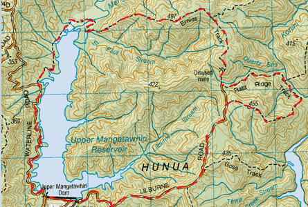
Head to the gate at Upper Mangatawhiri Dam (where you can park alongside the fence) at the end of ARA drive, off Moumoukai Road. We start off though a gate (pedestrian access only) on a gravel road that forks left (upwards) and right (downwards). We take the road to the left which is Waterline Road. After a couple of minutes of a slight upwards gradient, we are at the base of the dam and we pass a junction where Lilburne Road is on our right as we continue straight ahead.This road then levels out running along side of the reservoir.
After about 45 minutes we reach the sign for Ernies Track on the right. We head right and the track starts off down some stairs leading to a stream crossing which was close to mid calf level deep. Right from the start of this track we knew it was going to be a good one, as we were greeted by plenty of mud. There’s only a small bit of boardwalk (but not too much) over the swampy bits. It undulates slightly through lush bush and fairly low ground over a series of small shallow streams. At one point the track was quite spongey underfoot and the water was trickling down the track and there was plenty of lovely surrounding moss. After an hour on this track we stopped by one of the streams for a nice hot cuppa and some golden crunch cookies.
We continue on the flat track for about another 10 minutes and we encounter the Mangatawhiri River which was also about mid calf level. We carry on the flatish track for another 10 minutes or so and the track goes through a pretty cool bamboo part. It’s not long after that when the track heads steadily uphill at a reasonably steep gradient. This hill will give you a decent work out and it’s constant for about 45 minutes or so upwards. As we gained height, the views looking north west started to reveal themselves and the higher we got the better they got. There are a couple of grass clearings close to the top where you can admire the great view of the reservoir, the surrounding Hunua Ranges and right across Auckland and the Manukau Harbour to the Waitakere ranges. You can even make out the Manukau heads and the Twin Peaks of the Waitaks.
After the last grassy area with a big rock that made a cool seat, we headed up another bit of hill and back into the bush. From here the track undulated through the bush with some decent downwards and upwards track. After about 45 minutes or so after the last clearing with views, we reached another one looking over to the ridge we were looking out from previously as well as the great view from a slightly different perspective towards the Manukau Heads. There was also a bit of bush cover behind us, giving good protection from the wind, so we decided this was the perfect spot for our lunch of Omelette Sarnies & another cuppa.
From here it was back into the bush and downwards with a couple of steep bits. Here the track undulated yet again. After a while we pass the junction for the Upper Mangatawhiri track on our left. We continue on our undulating track passing a clearing until it gets a tad steep downwards again ,and then we come across some stairs and then a bit of gravel on the track signalling that we’re just about at the end of the track about 45 minutes later. After 3 ¼ hours from starting Ernies Track we reached just about the end of the track at a junction. Straight ahead up the gravel path, about 20 metres for the rest of Ernies Track, that then leads to Lilburne Road & also to Piggots Campsite (& Hut) and to the left is the start of the Rata Ridge Track (and thankfully no gravel). We head left.
This track starts off fairly level on just a slight downwards gradient. It’s nice & leafy underfoot and the track winds around the side of the ridge, at some parts it is a narrowish ledge. There are a few small trickling streams that we pass by each surrounded by lots of purple & green parataniwha. There’s also a wee water fall that we pass too. After about half an hour from starting out we reach the junction of the Mangatangi Ridge Track on the left. We continue past on this easy going track for close to 10 minutes. Then we come across a sign for the Rata Ridge Track pointing up a pretty steep bank. From here it’s a pretty hard slog upwards for a steady 45 minutes. Once at the top it’s only about 10 minutes of easy rack until we reach the end of the track 1 ½ hours from starting, where we come out at Lilburne Road heading left and right. We head left.
From here it’s easy going gravel road that starts of flatish, then slopes downwards at a pretty easy gradient. It’s not long before we get views of the reservoir. After about an hour we then reach the dam. As dams go (and I'm not usually a big fan of lots on concrete), this one is pretty cool. It has swans and a cool overflow/spillway and being Springtime we get to see loads of really cute lambs with waggly tails . Here we complete our loop with total tramp time about 6 ½ hours later.
Level of Difficulty
Moderate, with a couple of hard steep bits (clockwise)