Hapuakohe Range (north)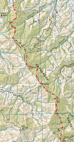
To tackle the Hapuakohe Range, you’ll need 2 cars.
This tramp is definitely a gooden and worth the effort. We parked the 1st car at the intended finishing point on the side of Ohinewai Road (off SH 27). This is a narrow winding gravel road with barely enough parking for a couple of cars roadside, close to the sign & steps for this walkway. Then back down Ohinewai Road and we headed to the end of North Road (also off SH 27) where there is also limited parking out of the way of the farmer’s gates. We head through the gate on private farmland following the direction of the signage. It starts off through a paddock on a farm vehicle track and heads into a pine forest past heaps of cool big orange toadstools (being autumn). After about 5 minutes or so the track heads off the vehicle track at a right angle and heads upwards. After a while the pine forest relents and we are in fairly dense native bush. We find that with the native bush, the birdsong serenades us as we make our way through. We also discover there is plenty of undulation on this track. After about an hour and a bit of up, we come out of the bush and enjoy our first of the spectacular views to be had. From here we see the Firth of Thames , the Coromandel ranges and a bit of the Kaimai Ranges (the rest obscured by trees) on one side of the Range. On the other is rolling green hills and farmland as well as Mt Pirongia & Mt Karioi. After taking in the view we push on. About half an hour later it’s time for Morning Tea. We realise there’s no view at this stage but we enjoy chilling out trackside amongst the paritaniwhas in the dense green bush, with sporadic sunbeams and the tranquil birdsong making for a perfect spot for a warming cuppa & raisin oat cookies. We then continue on the fairly easy going (for now) track and then after a pretty descent amount of up, the track briefly comes out of the bush again about 2 hours from starting out. Instead of following the track back in the bush, we decide to explore and follow unmarked ‘track’ upwards for a couple of minutes. We are rewarded by unobscured Eastward views. This viewpoint reveals a fair bit more than the last one and is quite stunning as it was a beautiful sunny day as well. This was a perfect spot leaning against the hillside for our lunch of Chermoula Sarnies. We could’ve easily spent a lot longer up here lounging about in the lush green grass (especially one of our hungover companions) soaking it all in, but this is a long tramp and being late autumn, daylight is limited. We made our way back into the bush and onto the track and made our way steadily downwards. After about 45 minutes we cross our first stream (actually where 2 steams meet) . From here it was steadily upwards again and after a while we come out of the bush and the track follows the fenceline. It’s not long before we see the slog ahead of the very steep grassy hill along the fenceline that the track follows. With this hill, you get a descent work out and you’ll feel the burn on the calf muscles. Up the top though, is some nice long grass to kick back in with another glorious view looking East. It’s also quite interesting seeing the contrast of the straight line along the contours of the hills and valleys where the bush meets the bare green grass paddocks. The exposed track continues to follow the fenceline for quite a while. We also get another view looking Westward. Past the cows & sheep, the rolling green hills & views beyond really are quite something. Eventually the track heads back in the bush, but we still find ourselves following a fenceline for a while. Once we leave the fenceline the track undulates a lot more and a fair bit steeper too. Despite the map, it actually crosses about half a dozen streams/creeks and some of the crossings where where 2 streams met. One crossing even had a couple of small waterfalls. These streams being in the bottom of valleys with dense bush (& lush purple & green paritaniwhas), the light was very dim. With each stream we encountered we knew it was going to be followed with another steep incline. As well as going up & down these valleys, part of the track is narrow & hugs the side with plenty of supplejack ready to trip you up if you’re not paying attention. On top of one of the valleys the bush became quite exposed & we could see we were right in the middle of the range again. In the last hour or so we could sense we were towards the end as the bush became less dense, making the track less defined & we had to keep an eye out for the markers. There was also quite an eerie light as well. Towards the end the track sloped downwards and there were a couple of steps indicating the end was fairly close. After just over 7 hours from starting out, the road revealed itself quite suddenly marking the end of our tramp. Directly across the road is the signage for the other leg of the Hapuakohe Walkway, but as the sun was going down, that’s a tramp for another day. |
Level of DifficultyModerate
Time7 Hours (Autumn 2013)
|
|
