Karangahake Mountain Loop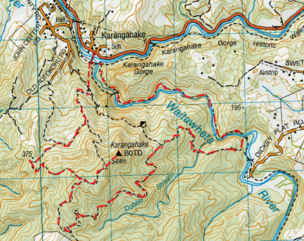
Head to the car park at Karangahake Reserve.
We start out on the suspension bridge that crosses the Ohinemuri River. On the other side, there are foundations of buildings that once were and a sign explaining stuff. There’s also a junction. Just about straight ahead and upwards, leads to Scotsman’s Gully Track and veering to the right is the Crown Tramway Track. We pass this junction and head across the Lower Waitawheta Gorge (suspension) Bridge. Across the bridge is another junction. Straight ahead is the Karangahake Gorge Historic Walkway and to the right is the Crown track which runs alongside the Waitawheta River. We pass by more foundations and a few information signs. There’s also another we junction giving you two different ways that loop, following this same track (via tram track or battery ruins). We keep alongside the stream and pass by more (battery) ruins. After a few metres the track goes upwards and come onto tram tracks. We follow the tracks with the river being on our right and it’s not long before the tracks heads more into the side of the gorge and then we pass through a small tunnel and then the longer tunnel known as Windows Walk. There is not much light in here, so a torch is recommended. Every 20 metres or so, there are holes in the rock on the right making windows allowing in light and also giving a pretty good view on the gorge and river below. The tunnel then curves to the right and soon enough we’re back in the light and heading down some stairs where the track continues. Also down the bottom of the stairs is a junction where you can head across a bridge to the other side of the stream. We keep on the side we’re on and continue straight ahead. This track keeps to the side of the stream offering nice views onto the clear water and the opposite side of the gorge. It’s also nice going through a wee bit of bush too. We pass a few mine entrances, most of them gated off. After about close to an hour there are some pretty cool rapids and small falls from where the Dubbo Stream meets the Waitawhetea River. The river also runs through a tunnel in the rock as well. After having a bit off a look around we continue on the track where it soon goes into another tunnel. This one is narrower and longer than the last one, so we were grateful for our torch as the end of the tunnel is a fairly small white dot and the it’s not quite flat underfoot. We found that it was best to give the torch to the person at the back, so the light shines forwards on everyone. After we came out of the tunnel, it wasn’t too long before we arrived at another suspension bridge, where the track follows across the Waitawheta River. Once across, the Crown Track ends at a junction about 1 hour and 20 minutes from starting out. The Dickey Flat Track was to the left and the Dubbo 96 Track was straight ahead. We headed straight. We leave the rumble of the river where this track heads into the bush with its birdsong and the track gently slopes upwards. After a while, the track then heads downwards to the tranquil stream crossing of the Dubbo Stream. We find this a great spot and pretty good timing for a cuppa tea with some golden crunch cookies. From here the track heads upwards again. About an hour from starting out on the Dubbo 96 Track, it ends at the T junction where the County Road Track goes both left and right. We head left. This part of the track is wide enough for a vehicle and slopes very gradually upwards. It takes a bit of time to get some height but eventually there are a few views when there is a break in the bush. After about an hour of this winding easy gradient we reach a cross roads intersection. Straight ahead is a distinct track and signposted as Unused Road (not shown on maps) On the left is the Mangakino Track and to the right the County Road Track continues (signage showing to Karangahake Summit). We head right and the track is slightly narrower, more of a bush track again. You’ll need to keep an eye out for the orange markers here as we saw there were a couple of unmarked tracks deviating from the path. After about 20 minutes from our last signposted junction we reach the end of the County Road Track at the T junction of the Karangahake Mountain Track going both left and right. Finally there’s a wee bit of mud up here, but not too much to get excited about. We head right. After a couple of minutes we come out of the bush to a pretty great view and we can also see the trig ahead, this is after the track goes downward into the bush and then up again. Also, to our hard right is another peak with a mast and solar panels. We head straight and it is a pretty narrow, rocky goat track. After about 10 minutes we come out of the bush at the trig. The view here is superb. You can see a fair bit of the Kaimais, the Te Aroha mast, Mayor Island, the Karangahake Gorge the Hauraki Plains and the sun glistening over the Firth of Thames plus the winding river amongst plenty of other stuff. We decide this is the perfect spot for our lunch and a nice hot cuppa. Refuelled we back tracked to the junction of where the Karangahake Mountain Track meets the County Road Track (on the left), but now we continue straight a ahead and follow the Karangahake Mountain Track. This starts off at an easy gradient downwards. On the way down we get a few more views and also pass another mine entrance. There’s another viewpoint that we check out, surrounded with heaps of gorse. The downwards gradient gets a tad steeper in parts, but nothing too tricky. After about an hour we reach the end of the track at the T junction of the wide County Road Track going left and right. We head left on the slightly downwards wide track (which is more of a road really). After about 15 minutes or so we arrive at another junction. The County Road Track continues straight ahead and the Scotsmans Gully Track on the right. We head right. This track is a narrower track with lots of pine needles under foot and runs alongside a tranquil stream with a small crossing. It also passes a derelict house. After another 15 minutes or so this track ends at a T Junction and we come out of the bush back on the Crown Track going left and right. Here we see the bridges that we crossed at the beginning and we head back down towards the bridge to cross back over the Ohinemuri River back to the car park. Total loop time. 5 ¾ hours. |
Level of DifficultyEasy
Time5.75 Hours (Winter 2012)
Additional NotesWe found the signage a tad ambiguous and even the topographic
maps a tad inconsistence to reality. We recommend you use the DoC Brochure map which is more accurate. http://www.doc.govt.nz/upload/documents/parks-and-recreation/tracks-and-walks/waikato/karangahake-gorge-brochure.pdf |
|
