Lake Wainamu - Kuataika Track Loop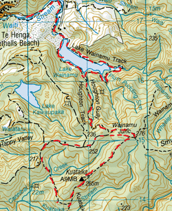
Head to the first Carpark at Bethells Beach, on the left just after the bridge over Waiti Stream. Pass through the gate where you’ll see the sign for the Wainamu Track.
This track just follows the stream. Being summer, the stream was low so we walk through the Stream with great looking reeds on the left. After a while the sand dunes rise up on your right, there is a farm to the left. We follow this stream for close to half an hour before we reach Lake Wainamu. We follow the lake heading clockwise where the track is now through the long grass. After close to another twenty minutes the track heads into the Manuka trees and a bit a mud, then up along the side of the hill, a tad steep on parts, before we come out at the first of 3 tranquil waterfalls with rock pools. We continue down and the track then flattens out through long grass along side of the lake & through patches of trees and some impressive looking pine trees too. After about 1 ¼ hours from starting out we reach a grassy clearing & a T junction. The Lake Wainamu Track continues straight ahead and the Houghton Track on the left. We stop here for a Cuppa Tea & some Golden Crunch Cookies. We then head left. The Houghton track starts of as it means to go on , upwards. This is a reasonable gradient for a good work out, it does ease up in parts, but is mostly just up. At one point the track turns a right angle past an unmarked track. There are also a few young kauris on the Hougton Track too. We pass a second unmarked track about 10 or so minutes later. After about 50 minutes from starting the Houghton Track we reach the cross intersection of the Wainamu Junction. On the left, the Wainamu Bush Track, straight ahead is the Smyth Ridge Track and on the right is the Kuataika track. We head right. The Kuataika track is quite a wide track (enough for a quad bike)with orangey brown clay. After just a few metres of starting out, we pass a locked gate on our right. We continue for about another 15 minutes until we reach the junction of the Kuataika Trig look out. This is an upwards rocky trail for about 3 minutes or so that reaches a remarkable panoramic view of the Waitaks & the ocean below. We then back track & head right & continue on the Kuataika track. After about another 10 minutes the track turns slightly & there is an unmarked track to the right. We head right. This track is pretty overgrown to start, with plenty of manuka, cutty grass & gorse. After close to 5 minutes it becomes even more overgrown that we almost contemplate turning back. We decide to carry on & push through as the mud track below is still visible whilst getting wacked & slightly cut by the surrounding manuka, cutty grass & gorse. This stage of the track is fairly flatish & there are no other tall trees. After about 15 minutes or so, the denseness relents, slightly -well the cutty grass & gorse anyway. The trees then get higher and the track then descends. It is difficult to see you footing as the kio kio ferns grow right over , covering the orangey brown clay track which also has a slightly deep trench caused by water running down when raining. After another 10 minutes or so we reach the bottom where the track crosses the Cannibal Creek which is very shallow. From here the track widens right out (enough for a quad bike) & there is long grass either side. Also the down up stream rule applies here. We head upwards at a steady gradient for another 15 minutes or so until we reach an unmarked T junction with a track on our left. We carry on straight ahead. After about 10 minutes we reach another wide grassy clearing of a T junction (also unnamed) with a track on our left & heading down hill. We stop here at this junction clearing for sarnies & a nice cuppa sitting amongst the tall grass. Afterwards we continue straight ahead at a slight incline. We follow this track for another 20 minutes or so and pass another unmarked T junction with a track on the left also heading downwards. We continue straight ahead and upwards. After a while the track flattens out a bit & then heads downwards until we reached a locked gate. We climb over this and we’re back on the Kuataika Track. We then head left and a few metres later arrive at the Wainamu Junction. We head left again on the Houghton Track & make out way back down. Being just about all down hill it only takes us just over half an hour to reach the T junction back at the Lake Wainamu Track going both left & right. Here we head left . The track continues lakeside through the long grass & past some great Pohutukawas. After about 20 minutes of so the track ends at the sand dunes that meet up with the lake. We can’t get out boots off fast enough before we dive in for a refreshing swim. One cooled down, we follow the lake side (continuing clockwise)along the dunes to where it reaches the river. We then backtrack through the Stream all the way back to the car. Total time, roughly 6 hours. |
Level of DifficultyModerate
Total Loop Time6 hours (Summer 2012)
|
|
