Marama Stream Loop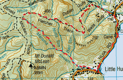
Head to Karamatura car park, down gravel drive off Huia Rd (opposite the museum).
From here we walk back down the drive and head right on Huia Rd. We walk along the road for close to half an hour. The views are across the harbour are quite something when the morning sun is shining. Once at Little Huia we head right into the paddock which is used as a car & boat trailer park for the boaties on their day excursions. In this paddock we see the end of the Marama Stream flowing out to the beach. We follow the stream upstream, cross a concrete bridge before heading into the stream where we wade & rock hop up the stream into the bush. On the way up we pass a few private residences whose properties back up to the stream, so keep to the stream so as to keep off someone’s back yard. One has a friendly dog, keen on a few pats. After close to 20 minutes the stream splits, we head right following the main water flow. After about another 20 minutes or so, the rocks get a bit bigger & we also pass the Barr Stream on our right. Also from here the stream gradient is slightly steeper, with more rapids, there is a fair amount of fallen trees & debris on the stream as well as plenty of parataniwha growing into the stream. We don’t see the next stream on the left (which is the Nutts Stream) as being midsummer it’s either died up to an unnoticeable trickle, or where it meets the Marama, may have been concealed by growth & debris. Soon the rocks become boulders and there is some pretty decent scrambling at times over boulders, slippery rapids & small waterfalls. The falls get a tad higher and more frequent. Our first real challenge was when the stream went into a narrow ravine where we had to wade through , until there was a waterfall ahead, we had to climb up the side to the right, about 10 foot or so, on the slippery moss where hand & foot holds were barely there, whilst the ones that were there were not too stable. There were no roots to hold on to, just parataniwha which don’t hold your weight, also making a bit of a balancing act as well as a scramble. Once up, we head along the side through the bush making our way past a couple more waterfalls. Once up it’s back down to the stream, until our next lot of waterfalls for more climbing & scrambling up, around & back in the stream again where it would allow. As for morning tea, we were pretty spoilt for choice for a scenic place to stop for a nice cuppa & some peanut brownie cookies. With stream tramps, I struggle to gauge time, as the mind goes into overdrive working out the next route around or up the next waterfall, and then there is also a wee bit of adrenalin with avoiding slipping & falling. After a few waterfalls we come to another ravine , this one is much larger with great mossy walls on either side and you guessed it, another waterfall ahead, and looking up, more beyond & up. With this larger ravine we found the best way up was to the right side. We lost count with the number of waterfalls. There was one that was just a mere trickle that went up at an angle so you couldn’t see the height from the bottom, but ended up being easily 100 foot. There was a way up on the side with the assistance of rock & kiokio and epiphytes. Once we got a bit of height we got one small view point looking out to sea. We also encountered 2 more splits that didn’t match up with the map. On the first split we headed right and the second we headed left, this is where our GPS really came in handy. Somewhere up here we stopped to refuel for a well needed & enjoyed lunch of Epicure Cheddar & Eggplant Kasundi Sarnies. Washed down by a nice strong cuppa. Continuing upwards past the splits the flow becomes less and in parts just a trickle, and the stream even full of more fallen trees & debris. Making your way over fallen trees can be tricky as most of them are rotten and do not hold your weight. As well as the obstacles in the stream there is also plenty of over growth to contend with (including supple jack & bush lawyer). At the top of another waterfall, just when we think we’d climbed them all, we discover wooden boards on the bed of the stream, being the remains of an old disused dam. We know we’re close to the top when we see a few Rimu trees about. After about 4 ¼ hours in the stream it funnily runs underground. We continue straight ahead & upwards up a valley and about 15 minutes later we reach the Fletcher Track going both left & right. We head right. The track at this point goes gently downwards before climbing upwards again with a few more Rimus. After while, to the right there are a few views to be had. First we see across to Mt Donald McLean, then there are spectacular views of the Manukau heads. After those viewpoints the track goes steadily downwards, fairly steep in parts. Somewhere on the way down we get the occasional view on the left of Huia. After about 45 minutes or so on the track we come across the part where the track splits at a really cool tree which looks to be as natures design of a seat. Straight ahead is a short track to a wonderful view looking over Huia and beyond and to the left and steeply downwards the Fletcher Track continues. It flattens off for a while and in this part the track goes right under a couple of massive trees making an arch right over the track. After that it’s downwards again, past lot’s of young kauri, there are also some nice views of the Karamatura Valley on the left. After about 1 ¼ hours on the Fletcher Track, it ends at the T junction of the Karamatura Track going both left (towards the Karamatura Valley) & right (towards the car park). There is also an unmarked track going straight ahead down to the Karamatura Stream. We head down to the stream to cool our feet & faces, then come back to the Karamatura Track and it’s now left that we head towards the car park. The track is flat and we pass over a small bridge and then arrive back to our car less than 10 minutes later. Total loop Time 6 ¼ Hours. |
Level of DifficultyHard with plenty of climbs & route finding
Time6.25 Hours (Summer 2013)
Additional InformationThere are 2 splits in the stream not showing on the Topomap.
GPS strongly recommended. There are lots of mosquitoes, repellent recommended. |
|
