Mt Kaitarakihi, Coromandel Ranges & back
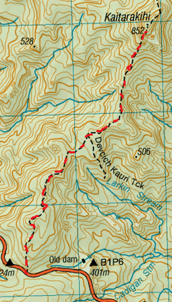
Head to the Carpark opposite the small yellow sign for the
Kaitarakihi Track at the top the Kopu Hikuai Road on SH 25A.
Heading East, the sign will be on your left & the Carpark on your right. This can be easy to drive past, there is space for a u turn further ahead, if you over shoot – but can be pretty dodgy, good luck. Even from the carpark across the road/highway, the track is consealed and it looks like there the sign is just pointing into the side of the hill with no track. Don’t worry the track is there . The track starts out at the base of the sign and slopes upwards. Straight away we find ourselves enclosed under the bush canopy. The track is mostly overgrown and obscured and there are plenty of hidden tree roots, vines & branches underfoot ready to trip up any unwary trampers. There is also a bit of supple jack to contend with too. To add to the fun there are plenty of branches & trees to climb over & under and as this track has not been maintained for some time, there are plenty of markers missing so you need to keep your eyes peeled. We found atleast 4 times, it seemed the track had disappeared due to fallen trees over the track and then plenty of growth on & around the fallen debris. You will need to keep your wits about you to re-discover the route especially as there quite a few points where the track is not defined. About an hour into this meandering and undulating track we pass the junction for the Devcich Kauri Track on our right. It’s not long afterwards that we contemplate morning tea. There was no real spot jumping out, but all our surroundings were lovely & green with plenty of birdsong & there were an abundance of sunbeams making their way though, so we stopped trackside for a cuppa along with some Almonds & Dried Apricots. Refuelled we carry on up & down veering left & right, after close to 2 hours we get a view of the steep ominous Mt Kaitarakihi ahead. After a bit more down, the track then heads upwards a tad more steeply and soon enough we get to a really cool steep bit right up the rock face where there are chains in place to help you hold on. Just after the top of the chains is where you’ll get your best unobscured view looking south & westward. The gradient then eases up a tad, but is still pretty steep. There are still a couple of tricky scrambles up between rocks. After another 15 minutes or so upwards we reach the summit, this making it about 2 ¾ hours from starting out. There is a sign here (but no trig) stating we’re at the summit & also the Hihi track continues for 5 Hours. There is a small clearing, but up here we are surrounded by trees except for a few trees cleared where you can look westward. If you climb on top of the wobbly sign you get a bit of a cool view looking East (It’ll take a bit of balance getting a pic). Instead of having lunch at the summit we head back down and stop at the best viewpoint about a minute above the chain. Here we kick back & tuck into our well deserved Beetroot, Feta, Mushroom & salad wraps. Afterwards we back track the way we came. Coming back down the chain was plenty of fun too. It was still slightly tricky going back though those bits where the track seems to disappear as the track looks different when coming back from the opposite direction. After about 5 ½ Hours we come out of the bush and arrive back at the carpark. |
Level of DifficultyModerate
Time5.5 Hours (Summer 2014)
|
