Pararaha Stream / Beach / Zion Loop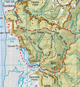
Head to the car park on Lone Kauri Road.
We take the Odlins Timber Track to the left. This starts off flattish, but soon proceeds to slope downwards and then down plenty of stairs. The track consists of orangey brown clay and can be a tad slippery, specially when wet. There is also plenty of delightful moss to be found trackside. After close to half an hour and lots of stairs, we reach the Pararaha Stream. We cross the stream and on the other side there is a junction. Straight ahead the Odlins Timber Track continues and on the right is an unmarked track alongside the stream. We head right. The track is thick with plenty of ferns and runs alongside the delightful tranquil stream. As the track becomes too dense, we cross over from side to side still making our way down stream. So far the stream crossings are pretty easy going, hopping from rock to rock. About a half an hour or so from starting out on the Pararaha Stream, the Cowans Stream flows into the Pararaha from our left. We cross over the Cowans Stream and continue straight ahead, downstream, also passing an unmarked track also on the left (running alongside the Cowans). We continue alongside the Pararaha Stream until we get to a point where we could hear the sounds of rapids and the track split and started the head upwards streamside as an option and the other option was to go down and into the stream for some rock hopping. We opted for going in the stream. It wasn’t long before we came to our first waterfall , reassuring us we made the right choice for what we were after. The track around the waterfall was a touch difficult close to the bottom and got our rock climbing skills into action as well as wearing a bit of mud. From here there are lots of stunning rapids and water holes, we had to stop frequently just to take in all the gobsmacking beauty surrounding us. After about 1 ½ hours from starting out we reached the trickling waterfall of a wee stream meeting the Pararaha Stream to the left. We’re pretty sure this is the bottom of the Walker Stream. Anyway this is a delightful place to stop for morning tea, so we kick back and enjoy a nice hot cuppa with some peanut brownies. We continue along our beautiful downstream route, rock hopping with the odd bit of wading, sometimes thigh deep making our way via plenty more rapids, small waterfalls and waterholes. We come across another couple of large waterfalls where the rock walls rise up on either side and we are now in a stunning gorge. We first have to make our way down the side of the ravine down a precarious goat track, then climb up on the other side utilising a board bolted into the side of the ravine, then climbing down the steep rocks, next to another fall which put our climbing skills into the next gear. From here it wasn’t long before we reached the last tricky obstacle, the log jam where we mix up rock climbing with making our way over some massive logs jammed up from the old logging days. Once passed here, it’s pretty easy going, we're now much lower down and there are plenty of Nikau and Puriri stream side. The stream and it surrounds are still very picturesque with plenty more boulders and rapids. It’s not long before we see a prominent track on the side, but we find it much more enjoyable to continue wading and rock hopping. At one stage towards the bottom it does get a tad deeper and we wade past our waists. After about 3 hours from the start of the stream we arrive at the junction of the Pararaha Valley Track crossing, going both left and right. We head right. This track continues alongside the stream (now on our left). We find a spot in some long soft green grass next to some flax right on the stream which is just perfect for lunch and a great place to admire the valley. Here we tuck into our Sarnies and a nice cuppa. We then continue on the Pararaha Valley Track for another 5 minutes or so over some boardwalk, crossing the marsh and we then reach another junction. To the right is the Buck Taylor Track and to the left Pararaha Valley Track continues. We head left and towards the beach on some more boardwalk with some cool reeds on the side. Then the track is sandy underfoot, follows some cabbage trees and also runs alongside a pond inhabited by a couple of black swans. There are orange markers (that also mark the Hillary Trail) easily visible and pretty well spaced that lead us onto the beach and around the marshland and pond. The beach track then heads inland again towards Tunnel Point covered in Pohutukawa and we reach a flat tranquil grassy area next to a pond complete with picnic table and long drop. There is also a big round rusty cylinder thing that must have been part of a steam train (as there was once a track here in the logging days). After that is a short tunnel going through the point that we continue through. We continue along the beach walking alongside the cliffs, passing a cool island that kind of reminds me of a battleship (known as Panatahi Island). After about 40 minutes or so from starting out on the beach we arrive at Karekare beach, we keep alongside the cliffs veering right and also following the signage. It’s not long before we see the sign a few minutes later for the Zion Hill Track on our right . We head right and are back in the bush. This track heads steadily upwards and there’s also a few stairs winding their way up the hill. There are plenty of Nikau about and there’s a wee valley down to the right where we hear the small trickle of a stream. As we get a bit of height we also get a few viewpoints of Karekare beach below. Soon the bush thins out and the track becomes quite exposed still heading upwards amongst Manuka and gorse. There is a small unmarked track on the right which leads to a viewpoint with a seat looking down at Panatahi Island and of course the beautiful surrounding coast. Soon enough the track goes back into the bush again, a few minutes later, there is another unmarked track on the right leading to another view point. This one is spectacular and looks south west towards the coast that we had previously walked and towards Whatipu . From here the track still continues upwards, the gradient isn’t too bad and there’s a bit of mud underfoot too. After about 40 minutes from starting this track we reach a junction. The Zion Hill Track continues straight ahead and the Zion Ridge Track starts on our left. We head left. This track is reasonably flattish, with just a slight incline. Underfoot is just slightly muddy with a carpet of leaves from the magnificent Puriri trees about. Occasionally there is a gap in the trees offering a view. In less than half an hour the Zion Ridge Track ends and we reach our next junction with the Buck Taylor Track going both left and right. We head left. From here we come out of the bush and pass through a type of long grassy meadow and then downwards through some Manuka that becomes a bit tunnel like. After about 15 minutes or so we reach the car park. Total route time, about 6 hours. |
Level of DifficultyModerate to Hard, with rock climbing
Time6 Hours (Spring 2012)
|
|
