AhuAhu - Comans - Mercer Bay Loop track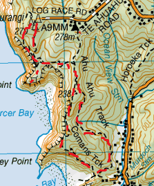
Head to the end of Log Race Road (on the way to Piha), at the end there is a car park.
From this car park is the start of the Mercer bay Loop Track, which starts from either side of the carpark (being a loop). We headed to the left (with the road being directly behind you) and down the grassy bank where you will spot the track. As you get further down you get to a T junction, the Mercer Bay Loop track going both left & right. At this point we head left in the direction of the Ahu Ahu Track. You’ll walk along a wide track that head upwards and is adjacent to the cliffs of Mercer Bay (being below). About 5 minutes or so you will come across the Ahu Ahu Track going both directions (left, up towards Te Ahu Ahu Rd & right, down towards Karekare). We head right and down, as it was mid winter this track had a wee bit of mud. We continue down for another 5-10 minutes and was pass the junction on the right of the Comans Track, we continue down the Ahu Ahu track. This track is all down and pretty wide (accessable for a quad bike). Before you know it you are getting a few glimpses through the trees of Karekare Valley below. After about 40 minutes from staring out we reach the bottom of the track & arrive at a Pohutukawa glade. We also see the track for the Comans track on our right heading towards the beach. After exploring the glade, we head right and up on the Comans track . As soon as you get up out of the trees you are walking on the cliffs overlooking Karekare beach. This track keeps close to the edge of the cliff and heads up steadily and steep in some parts. The views on this track are spectacular, and the higher you get, the better the views are, revealing more and more. After close to 40 minutes or so we get to the top where there is a lovely green grove littered with leaves on the ground, A cool big tree and a few Nikaus. It was up around here that we found that it was a great spot for morning tea. The track then continued up a bit more, in the bush and then back down again and alongside the cliffs now overlooking Mercer Bay. The track then heads back in the bush going downwards until the track pops out at the Junction of the Ahu Ahu Track (which heads left and right). This time we head left and back upwards. We retrace our steps heading around Mercer Bay and left back on to the Mercer bay loop. When we get to the junction to head back up towards the car park (on the right), we continue straight on adjacent to the cliff. Continuing on we jet to another junction, right to follow the Mercer Bay Loop and left towards Te Ahua point. We head left and down the path and some steps and get out to this point. We come across a cool Maori caving and a railed look out right on the edge at the wild sea below and the imposing cliffs to the side. This was pretty cool, even though it happened to be raining sideways at the time. From here we back tracked upwards and took the path not yet taken on the Mercer Bay loop. The Mercer Bay Loop track is a nice easy walk with gentle slopes and great sea views along the cliff side and amongst plenty of Cabbage Trees & Manuka Trees (as well as plenty others). Before we know it, the track curved in and we were back at the car park on the opposite side from where we started. This loop in total took about 2 ½ hours and is good if you’re starting out and just getting the feel of tramping. |
Level of DifficultyEasy
Total Loop Time2.5 hours (Winter 2011)
2 hours (Winter 2013) |
|
