Chateau Mosquito - Simla - RGB Track Loop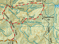
This is a great loop if you want something fairly short, yet still a little bit challenging .
Total loop time about 3 ½ hours (Clockwise). If you do this track Anticlockwise (starting with the RGB), it is slightly quicker although the Chateau Mosquito has a lengthy uphill climb – total loop time about 3 hours From Anawhata Rd This Chateau Mosquito starts off on a fairly wide flat track , that slowly starts to slope upwards & ground becomes fairly hard orange clay (& at times slippery) for about 30 mins. Along this bit you’ll pass the junction for the RGB on the right. You’ll also find you may have an audience of a curious Tomtit or Faintails investigating. Finally the track closes in & the bush become dense lush & green with plenty of nice moss amongst plenty of other cool stuff. As well as your footing, watch your head as there’s plenty of interesting flora & fauna & fallen trees to go through & duck under as well. The track then descends quite steeply toward the Anawhata stream. This stream crossing is very picturesque & looks across at a wonderful great big moss covered rock & the trickle of water on the stream rocks. The track takes you along side of the stream for a few minutes, then down to the stream again to go alongside it walking precariously along a slippery rock (just look out for the bright markers where to go) before ascending up the valley again (back to the rule if there’s a stream there’ll be a “down” then an “up”. After this steep scramble you come across the end of the track (approx 1 ½ hrs) & a junction between the Sisam Tk & Simla Tk. This time we head down the Simla Track. The start descends pretty steeply & you can hear the water of the Smyth Stream almost straight away, you get to the bottom in less than ten minutes. Here is an old log jam / stream crossing & is at the top of a water fall. This is a beautiful spot for a nice cuppa tea on the rock at the streamside. Refuelled fully aware of the climb ahead we set off up the steep track. At one part, the track is over the rocks & is close to vertical. This track is mostly up. Once you get to the top, you’ll know because there is a small grassy clearing here with great views of the surrounding valleys of the Waitaks below. From here it’s about another 10 minutes of flatish track until you reach the T junction of the Long Road Track (going left & right). The Simla track took about an hour. We head right . The Long Rd Track is pretty wide & straight with a bit of mud & great big puddles (in the Winter). After about 15 minutes or so we come across the RGB track . The RGB starts off pretty easy & flat, then gets pretty damn steep, there’s plenty of roots to hold on to, but sometimes you need to make some pretty big steps (climbing down can often put a lot more excursion on ones legs than climbing up – you’ll see what I mean when you do it). At the bottom is this is where the Pigs Wallow Stream meets the Browne Stream with little waterfall/rapididy things. There’s a wee pool here for those who might be considering to cool off. As it was mid winter, we admired its beauty & moved on remembering the “down/ up “ rule of streams & that we had another climb ahead. This was another steep climb, you could definitely feel the burn on your thighs especially after making some pretty big steps in places. Once you have the reward of getting to the top of the valley the track continues for a couple of minutes until you come out at the Chateau Mosquito again (about an hour later). We turned left & headed for the car . |
Level of DifficultyMedium -both directions
Total Loop Time3.5 hours -clockwise (Winter 2011)
3 hours -anticlockwise (Summer 2011) |
|
