Gibbons - Muir - Pararaha Valley - Whatipu Beach Loop Track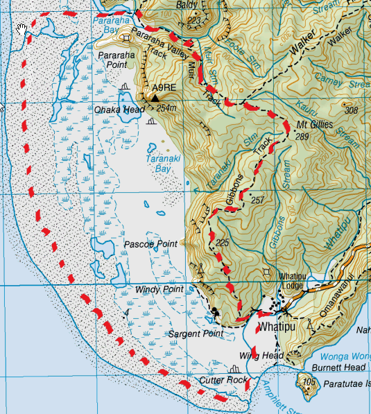
Our First Tramp:
After doing a bit of research on the Auckland City Council site we all agreed that the Gibbons track in Whatipu looked like a great track to start off with. Described as "a great track for getting views over the Whatipu wetland" and only having one steep climb after which point it's fairly level and being two hours, it was the perfect first track for us...little did we know what we had in store. You start off at Whitapu car park and wander around looking for a map to work out where the tramp actually starts. Once in the carpark at Whatipu, walk towards the information hut (we were very surprised that the information board had no site map of where tracks are) and facing the hut, walk along the fence-line on the left hand side of the hut, towards the hill (northwest). You will need to climb over the first fence stile and keep following that fence-line across a wee boggy (well it was mid-winter) paddock. This will lead you to another fence heading right where you will see another fence stile to climb over. You should now see the start of the Gibbons track ahead. We were doing this track after a couple of days of very heavy rain so we weren't sure what to expect with regards to muddiness or slipperiness. As it happened, it was very muddy and very slippery! You start by heading up a slightly steep hill, upon clearings some beaut views overlooking Whatipu beach and entrance to the Manukau Heads. Once up the top, we walked along a ridge with plenty of great beach/sea views. This track had plenty of mud and some pretty deep muddy puddles adding to the fun. Being our first tramp we were pretty much in awe of everything around us and just thrilled to be actually doing something (instead of just sitting around talking about it). There were heaps of different types of trees and other nature bits but we didn’t take too much of that in. On the ridge there were plenty Manuka or Kanuka trees (struggling to tell the difference). At the end of the Gibbons (about 1 ¾ hrs) we got to the track junction. We headed left on the Muir track. This is all down, apart from a beauty lush, deep green nikau stream bit,which is pretty level. We’ve learnt if there’s a stream there’s a “down” to get to it and an “up” to leave it - except on this occasion where the water goes right off the edge of the cliff. Towards the end of the Muir it gets pretty steep and you get to clamber down a rock face holding on to rope bolted into the rock for a few metres (cool). The views of the Pararaha Valley from there are spectacular. This track then zig-zags to the bottom where (about ¾ hrs) we came across a grassy clearing by the Pararaha stream. There’s a shelter (concrete floor & roof) and another grassy clearing by the stream if you fancy a spot of camping. There is a junction here where the Pararaha track goes both directions (right heads up the stream and valley –connecting to Odlins Timber Track). We headed left on the Pararaha Valley track and we then came across a stream crossing. Being mid winter and after plenty of rain the stream was pretty swollen and deep. We did attempt to find an alternative route, but don’t bother. This crossing is your best bet, as we discovered after an attempt to cross elsewhere (we were thinking maybe we could cross walking on the big tufts of flax). Do not do try to do this. We found that you end up sinking down into the marshes and with the flax being very high you can’t see a thing. It can become a maze in which you can get disorientated and just end up going around in circles . Thus we learnt the golden rule DO NOT LEAVE THE TRACK. We were aware of going off the track, so tried to remain as close to the stream as possible to avoid losing our bearings. By doing this we were able to follow the stream along and came back where we started...rather dishevelled and a tad knackered from our bushwhacking whilst wading in the boggy parts of the stream. After crossing the stream where the track leads (which ended up being waist deep even with the assistance of crossing on some reeds) we headed left towards the beach (Parahara Bay) which starts off as a pleasant boardwalk. We then passed the junction to the Buck Taylor Track on our right. We thought at this point we had pretty much completed most of our adventure...it had been close to 4 hours by this time - due to our stream crossing detour - on a walk we only anticipated being 2 hours. With only a short walk on the beach to get back, we were pretty thrilled....how naive we were. The pleasant boardwalk finishes and leaves you to make your own way through the marsh. Just getting to the beach we discovered was quite a mission. Once on the sand we headed left (for the return part of the loop) and it's there that you find that it’s a hell of a long way to get back to Whatipu. The end is not even visible at first and you can’t walk in a beeline towards your destination because of the maze of marsh and sand dunes. This beach walk seemed endless, the chirpy conversation ceased, the feet were dragging and budding blisters were emerging. We hadn't taken anything to eat or drink on this tramp with us as we only anticipated being out for two hours. So as you can imagine, we were getting pretty hungry and thirsty and our enthusiasm was starting to wane. We have re-named the walk on this park of the loop “The Beach of Despair” as it just seemed to go on and on. In total this loop was around 6 hours. This was our first tramp and we didn’t really research it, we were intending to go on a 2 hour tramp and the internet said Gibbons track 2 hours. What we didn’t do is take into account is that the 2 hours didn't relate to the loop that you need to do. Needless to say, without this experience, it may have taken us a few more tramps to learn some very valuable lessons in tramping. So in many ways, it set us up for what has become an immense passion for all of us. The best thing is that, while we were tired, worn out, hungry and thirsty at the end of this tramp, we were still keen to get straight back out and do it again....better prepared, of course |
Level of DifficultyMedium
Total Loop Time5.75 Hours - anticlockwise (first time -Winter 2011)
4 Hours - anticlockwise (a tad fitter -Winter 2012) 4 Hours - anticlockwise (Autumn 2016) |
|
