Huia Dam Rd - Christies - Summit - Nihotupu - Parau Loop Track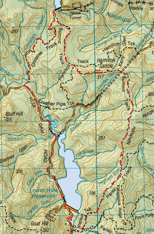
Head to Carpark at the Huia Dam Road.
Through the locked gate (pedestrian access only), this is a pleasant stroll up the sealed road. Firstly you head up the Lower Huia Reservoir dam then from there on this road is then unsealed. You walk alongside & across a couple of bridges, then the road slopes upwards. The road forks (Smiths road to the right), we carry on straight ahead and across another bridge. The water is very peaceful & reflective of the scenery around & you can see the odd fish movement in the water. From here there are high banks on either side covered in moss & the trees are overhead forming a nice green canopy. We pass the Crusher Pipe Track on the left, before finally reaching the Christies Track also on the left (about 50 minutes from starting out). This heads immediately downwards towards the stream. This was on New Year’s day, just after all the rain so the river was running fairly fast & was just over boot level deep (so I gather it’s usually a pretty easy crossing where you can keep your feet dry). After crossing the Huia Stream, there is a slight incline and it’s not long before we hear the next stream (McQuillam Stream) curving around. This stream, we walk along side which is a few metres below the ledge of the lush track. We continue more or less flat-ish (only slight inclines & declines ) on this densely green bushy ledge type track with plenty of roots & rocks underfoot & plenty of moss & mud. There is also plenty of water trickling down making small waterfalls & streams to cross over due to the rains. The Waitaks are even more appealing after rain, the greenery (especially the moss) is a lot more vibrant & it’s great to have plenty of deep muddy puddles. After a while we approach the Christies Stream (which runs into the McQuillan Stream) and the track is adjacent to this one for a while. We found that there was no particular clearing for a morning tea stop with this track, so we happily stopped trackside once the need for tea & golden crunch cookies was upon us. This track goes steadily slightly upwards with plenty of bits to climb over & trees to duck under & plenty of twists and turns making it a very enjoyable one. After about 1 ¾ from starting out on the Christies, we came to the junction for Upper Nihotupu Dam straight ahead & the Summit Track on our right. We head right. This climbs up straight away at a moderate incline. In between gaps in the trees you can view the dam & the great valley below on your left. We found we made a fair bit a height pretty quickly and then it undulates up & down a few times. After one of the declines we pass the junction (with a sign/map) for the Hamilton Track going both left & right. We continued straight ahead on the Summit Track. We found at the top of one of the peaks there was a pretty good clearing trackside for some Sarnies, Cuppa & some Christmas Scroggin. We also noticed that higher up the trees were less dense, but there are also lots of thick vines to contend with. With the trees being less dense we found the track poorly defined & had to really keep an eye out for the markers as it was pretty easy to go off the track. After about 1 ¾ hours from starting the Summit Track we reached the T junction of the Nihotupu Ridge Track going both left & right. We headed right. This part of the Nihotupu Ridge Track is still pretty poorly defined so you have to stay vigilant for those markers (especially when the track appears to split). This track also undulates for quite a while and ended on a downwards part approx an hour from starting out. We had then come to the T junction meeting up with the Parau Track (going left & right). We headed right and about 5 minutes later we passed the Kakamatua Ridge Track on our left. We then noticed the track heading downwards at a steady gradual gradient. After a while the track became a more of a pathway . Towards the end we encounter the junction for the Farley track on the left, we continue on the Parau Track then after a few minutes across the swing bridge across the river and come out on the Huia Dam Rd again, then we head left back track to the car. Total Loop time 6 hours. |
Level of DifficultyModerate
Total Loop Time6 hours (Summer 2012)
|
|
