Mt Auckland Walkway and back (Kaipara)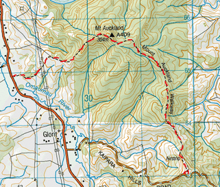
Head to the Mt Auckland Walkway Carpark on Kaipara Hills Road (off State Highway 16).
We start out on farmland over the stile and head up a gravel drive lined with Cutty Grass and Toi Toi. As you get up the top of the drive you have views on the left of numerous Toi Toi in the valley below and some pretty good views of the Kaipara Harbour beyond. Also at the top of this drive is a fairly new loo, straight ahead is a disused red barn. We head left following the orange markers and walk alongside the small grassy sloped airstrip. Being mid winter it’s pretty boggy and the mud has a good go at holding on to your boots. Also the view to the left is hard to keep your eyes off. We head downwards and pass through a gate downwards and cross more boggy paddock with plenty of presents left behind from the cows, then it’s up a pretty steepish bank. After about 20 minutes of farmland we climb over another stile and then enter the bush of the Atuanui Reserve. This bush has a great vibe with plenty of Ponga, Taraire, Nikau and Puriri, amongst other stuff. The track starts off relatively flatish with a slight incline upwards. But does undulate a wee bit as well, but nothing too difficult on this side. There are plenty of tree roots (some with pretty cool moss and fungus) underfoot as well. There’s also a couple of massive fallen trees that we make our way around, so you can get an idea of what this forest would have been like before the pioneers came along. We do come across an unmarked path on the right but there’re orange markers to keep you on track pointing left. There’s also a No Exit sign a couple of metres down in case there are any doubts. Anyway after a wee downwards spell followed by it bit of up, we arrive at the summit, an hour and 10 minutes from starting out. There’s a Trig here and also a lookout tower. There’s great view of the surrounding hills of the country side as well as a bit of the Hoteo River below and a bit of the Kaipara Harbour too. There’s not a 360 degree view as some of the trees cover a portion of the Kaipara Harbour. On the opposite side you can make out Little Barrier Island and you can even see the Whangarei Heads. We didn’t linger though as there was rain heading our way. The track then continues back into the bush on flat track (with a wee bit of mud too), before heading downwards. This slope starts of pretty easy at first before getting a tad steep and a bit slippery underfoot too on a fairly narrow ridge. We discover a small grove of Nikau protected from the wind and we settle down on some brown dead branches for a dry seat to enjoy a nice hot cuppa and some golden crunch cookies. Refuelled we continue on our way and pass by some massive Puriri Trees, there are also a few more views to be had in between gaps in the trees too. After about 40 minutes after the summit we come out of the bush cross over another stile and we’re on more farmland in a paddock. We head up a small slope and are greeted but another great view of the surrounding Kaipara Harbour. We follow the orange markers, head through plenty of mud and pass some massive pylons and then some surly cows. About 20 minutes later we arrive at the end of the track at a carpark down a small gravel drive off State Highway 16. There’s also an identical new loo here too. This track took us a total of about 2 ¼ hours. We then turned around and headed back to try the track from the other direction – always nice to get a different perspective. Heading back up took about the same time but it was fairly steep going. An hour later we were back at the summit. The weather was clearer this time, so we stopped for our lunch of Moroccan Avocado Sarnies and a nice hot cuppa, whilst enjoying the view. From here we continued back tracking and found from this direction the time was about the same. Total track time there & back was 4 ½ hours. |
Level of DifficultyEasy (with a few steep bits)
Time2.25 Hours - One Way (Winter 2012)
4.5 Hours - Return (Winter 2012) |
|
