Pararaha Stream Loop (& Baldy)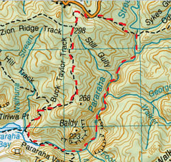
Head to carpark on Lone Kauri Rd.
Start out on Buck Taylor Track straight ahead. The beginning of this track is through a kind of tunnel of Manuka trees and there is a slight incline. Afterwards the canopy dissipates and it becomes a country walk on a hillside overlooking paddocks & bush. Before you know it, you are back in the bush again & the track heads downwards. After about 15 minutes from starting out is the junction for the Zion Ridge Track on the right. We continue on the Buck Taylor track straight ahead and downwards . As the track gets further down, the canopy overhead thickens & and the downwards gradient gets steeper. The track has more roots & rocks to scramble down & the trees get noticeably larger and with the denser canopy the light is also a tad dimmer. There’s plenty of cool rocks & moss, Puriri & Nikau Trees and Wood Pigeons about too. As the track continues there are a couple of viewpoints where there are gaps in the trees & you can look out below to the stream & wetlands of Pararaha Bay. After about 45 minutes from starting out you reach the end of the track at the junction of Zion Hill Track on the right and the Pararaha Valley Track veering slightly left. We head down the Pararaha Valley Track. The track continues downwards and the bush thins out giving way to manukas & flax with rock face on the left. We pass the junction on the right leading towards the beach (which was pretty flooded from previous heavy rains). The track then is a boardwalk over the marsh and with reeds & grassy stuff on the right. After the board walk the track is sand & mud & widened for quad bike access. We also enjoy looking up at the rocky cliffs either side of the valley, especially the rock known as “Baldy” which from some angles looks like a gorilla & other angles looks like Jabba the Hutt. After about 10 minutes or so from starting this track we cross the Pararaha Stream which happens to be just over boot level , so we get wet feet. Don’t bother taking your shoes off as they’re going to get wet later on anyway. Continuing on further, on the other side of the stream is the a grassy clearing with the Les Ward Hut on the right (as well as the route leading towards the Muir Track) & the camp site next to the stream on the left. We veer down & left and follow the stream. This track starts out easy enough alongside the stream and then appears to end. This route is pretty much just heads up the stream, hop across on rocks where you can, wade where you have to (you will get wet feet) and every now and then a track will appear (keep your eyes peeled as they could be on either side & there are no markings) when the stream gets a tad too deep. There’s a plethora of beautiful places to stop for lunch. We find a perfect stop on the side a some flattish rock for our Parmesan & Salad Wraps. This route is a lot of fun making your way along rocks and over rapids and the scenery is spectacular with the valley walls on each side, the water, the rapids, the sun reflections, the trees ,etc. It’s all pretty tame until you get to the log jam (and one of quite a few waterfalls). There’s some great big old logs that must of been here since the old milling days. We noticed that the log jam has moved a bit since our last couple of visits and now the climb over the logs is even slightly more precarious. You really have to have your wits about you from this point on. You’ll need to do a bit of rock climbing and really pay attention and watch where you put your hands and your footing. With the additional volume of water these rocks are really slippery. Also as it had been raining previously and the river level was higher than we’ve seen before. The waterfalls had heaps more water coming down then than usual, making our climbing just that little bit more difficult with the water gushing beneath us. Now for finding the track you also need to look up (as well as side to side) to where any part looks slightly worn or trodden on. You’ll have to do more scrambling and rock climbing and even once up these ledges, they are pretty precarious goat tracks and also parts where you need to scale the side of the rock to avoid wading in deep cold water (being Winter) . Once up you look down at the falls (and the drop to the rocks and deep pools below) and also constantly keeping an eye on your footing to see what you’re actually standing on. Our route also entails a couple of narrow planks bolted into the side of the cliff and thankfully a black cable to hang on to. From here we head down and there’s a rope to assist the descent. The we cross again & up and over another goat track. From here it all seems pretty tranquil for a while until you get to a couple of narrow channels that you have the option of wading, scaling the side of the slippery rock walls or back tracking a wee bit and make your way up a steep narrow goat track. After the 2 channel bits is the last waterfall for our route on the Pararaha Stream with a couple of options upwards. After that we follow the track alongside the stream until we pass another track on our right which heads up towards Cowan Stream. A moment later we cross the Cowan Stream feeding into the Pararaha Stream. We continue straight ahead. 10 minutes or so later we come the end of the Parahara Valley Track where it comes out at the T Junction of the Odlins Timber Track heading left & right. We head left. Then it was up for close to half an hour of stairs and back to the car Total tramp time 4 ½ Hours. |
Level of DifficultyHard
Time4.5 Hours - anticlockwise (Winter 2013)
4 Hours - anticlockwise (Summer 2014) 4.25 Hours - anticlockwise (Spring 2014) 4.5 Hours - clockwise (Summer 2014) 4 Hours - anticlockwise (Summer 2016) 4 Hours - clockwise (Summer 2016) BaldyTo access the start of the climb to Baldy you head down the Buck Taylor Track for about half an hour. Just after your first partial view of the coast, the track veers left a right angle. Moments later the beginnings of a slight creek pass over the track. It is at this point where you leave the Buck Taylor Track and head left up the hill. This is an unmarked route & will take either a whole lot of observational skills, otherwise a GPS will really come in handy. Once you reach the top of the hill, you head down a and then up again. The "track" is obscured by bush & there is plenty of scratchy manuka & gorse about. After close to 40 minutes we reach the top of Baldy. The view is pretty good, but not quite as cool as we anticipated. It's not really bald up there either, there is plenty of growth, but there are still a couple of cool viewpoints for lunch & a cuppa.
Level of DifficultyModerate - although route location can be tricky at times
Time
40 minutes each way (return a tad quicker as you know where you're going).
Winter 2015 |
|
