Pararaha Valley Circuit.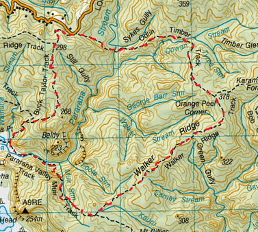
Head to Lone Kauri Road Carpark.
At the track entrance you’ll encounter two tracks. On the right is the Buck Taylor Track & on the left is the Odlins Timber Track. We head left. After you turn the corner past the road you’ll find lots of stairs, all different widths & with slippery orange clay heading downwards. 15 minutes later we cross the Pararaha Steam & we pass the unmarked Pararaha Valley Track on the right. From here the Odlins Timber Track is mostly upwards with plenty of orange slippery clay. As you get a bit of height, views of the Baldy & parts of the Pararaha Valley are revealed to the right. There is a wee flat dark swampy part, then a wee creek before a downwards slope to the Cowans Stream (which is about 25 minutes or so later from the Pararaha Stream crossing). Just before the stream your pass the unmarked Cowans Stream Track on your right. Just across the stream on the right is a camping ground with a loo. This makes for a reasonable spot for morning tea. From here it’s another half hour up the clay track until we reach the end of the Odlins Timber Track at junction of Orange Peel Corner. To the left is the Walker Ridge Track (heading to Karamautura Forks) and straight ahead is also the Walker Ridge Track which heads to the ridge. We continue straight ahead. The is a gradual incline & perhaps too many platforms covering the glorious mud. After about 15 minutes there is a clearing which reveals some great views of Whatipu to the left & of the Pararaha Valley to the right. The track heads down fairly steeply, then plenty of uphill. After about 30 minutes we reach the top where there are some Pines Trees with pretty cool nobly roots underfoot. Then it’s downhill for about 20 minutes on some slippery clay, some parts are a cool reddy orange before it flattens out until the end of track. We then reach the next junction. To the left is the Gibbons Track & straight ahead is the Muir Track. We head straight. This starts off downwards, we cross a small creek where it’s vibrant green with dense ferns amongst Puriri Trees. Then the track runs alongside the creek. After about 25 minutes we come out a rocky outcrop with an awesome view of Baldy and up the Pararaha Valley and beyond. This was the perfect spot for lunch of egg mayo & dried smokey coconut sarnies. Afterwards it’s just another 15 minutes steeply downwards, starting with a chain for climbing down the steepest rocky part, then a zig zagging track which comes out at a long grassy meadow at the bottom of the valley. The Muir Track ends at a junction and camping ground (along with a loo). You’ll encounter the new Les Ward Shelter (now with bench, sink & tap) on your left. The Pararaha Valley Track actually heads both left & right. The direction of right heading up the stream is not signposted (& follows all the way up the Pararaha Stream). We head left & past the shelter down the sign posted part of the Pararaha Valley Track. This is flat & runs alongside the stream with flax either side underneath Baldy looming overhead. The track crosses the Pararaha stream which was just below knee height (so yes, you will get wet feet). We then continue alongside the stream and come across boardwalk over swamp & there are reeds all about, out to Pararaha Bay. After about 15 minutes on this track we reach another junction. To the left the Pararaha Valley Track heads out to the beach and straight ahead is the start of the Buck Taylor Track. We head straight. There’s more boardwalk , reeds, flax & cool rocky cliffside before we head up into the bush. Once in the bush there are plenty of cool Puriri about, it gets steep in parts with roots underfoot too. You will also get some rewarding views out toward Pararaha Bay & beyond. After 15 minutes on this track we pass the junction of the Zion Hill Track on the left. We continue straight up the Buck Taylor Track. There is plenty of up , a bit of down & more up. The canopy overhead is quite thick so the light gives a cool green hue in parts. After half an hour we pass another junction of the Zion Ridge Track on the left. We continue straight ahead on the Buck Taylor Track and we come out the bush to views of farmland, then its downwards through some Kanuka trees and we reach the carpark 10 minutes later. Total Tramp Time 4 ½ hours. |
Level of DifficultyEasy to Moderate
Time4.5 Hours (Winter 2015)
|
|
