Puriri / Kura / Gibbons / Walker Ridge / Donald McClean Loop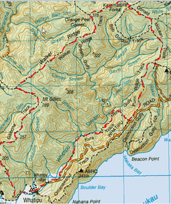
Head to Carpark at end Mt Donald McClean Road.
There is a track (on the Opposite side of the carpark from the walkway up to Mt Donald McLean summit) that heads down a small bank. Once down there a couple of metres you will see a sign straight ahead for the Donald McClean Track going into the bush. A few more metres in and you will see the Sign for the Puriri Ridge track on your left. We head left . This track starts off fairly flatish with a nice bit of mud , inclines slightly upwards then, goes steadily downwards. At one point there is a clearing where the track is just rock & you get a pretty good view of the surrounding Waitaks & the valley below. This track continues downwards past some Kowhai Trees. After about 45 minutes we come across the a junction where the Puriri Ridge Track continues straight on & left and the Kura Track starts on the right. We head right. The Kura starts off downwards straight away down into the valley we were just looking at previously on the rock clearing. You make your way downwards fairly quickly,as this track is a tad steep & can be pretty slippery on the mud & roots when raining. We pass a couple of small waterfalls/ streams & then we make our first (of 4 river crossings). The first one we decide is a peaceful looking spot (and also has a bit of shelter under a fern from the rain) for a cuppa & some Golden Crunch cookies so we can soak in our surroundings. The next 3 crossings are in a fairly quick succession of one another, then continues flat & very easy going alongside the Whatipu stream. You’ll pass more Kowhai & plenty of Nikau and then head through a gate and out into a paddock along the fenceline until you reach the road where this track ends (about just under an hour from start of the Kura). From here we walk down the roadside towards Whatipu carpark looking up at the ominous peaks of Omananui Track above on the left. Once at the carpark we head past the information kiosk on our left and follow the fenceline (on the right)of the Whatipu campground . We followed the fenceline of the campsite towards the hill on the opposite side of Omananui & head northwest. Then up a slightly steep hill, with dense bush overhead. Upon reaching close to the top, there are plenty of exposed parts of this track through flax & some beauty views overlooking Whatipu beach & entrance to the Manukau Heads. Once up the top, it was along a ridge with plenty of great beach / seas views. This track had plenty of mud & some pretty deep muddy puddles (some of them deeper than they look) adding to the fun. There are plenty of Manuka trees that kind of form tunnels which the track goes through too. At the end of the Gibbons (about 1 ¾ hrs) we reach the T junction. The Muir Track to the left & the Walker Ridge Track to the right. We head right. This track starts out pretty flat & with plenty of muddy puddles when wet (yup, still raining) . There are also plenty of Kio Kio Ferns all along this track. Then the track slopes upwards and the reddish-orange clay, when wet forms a wee stream down the centre and also pretty slippery in the wet. We come across some pretty big pine trees with cool knobbly roots . There are also a few ferns here as well for a bit of shelter, to tuck into our Chermoula sarnies & a nice hot cuppa tea for lunch. After the pines, the track closes in a bit & there’s big grassy stuff (& more kio kio ferns) on either side & then it descends at a reasonable gradient before heading upwards (slightly steep) again. This down & up bit is also exposed and has some pretty good views of the bush & the sea behind you. After the ascent, the track flattens off again and also there’s plenty of mud & deep puddles & tree roots. As you get further along, the bush becomes more dense. After an hour from starting this track we reach the junction of Orange peel corner. To the right the Walker Ridge track continues towards Karamautura Forks & straight ahead, the Odlins Timber Track begins. We head right and continue on the Walker Ridge Track. This starts off with some pretty big kanukas (amongst heaps of other stuff) and then heads downwards through dense kio kios on either side, there’s plenty of roots underfoot too. After dipping down a fair bit, the track then slopes back upwards again. About 20 minutes from the Orange Peel Corner we reach the T junction of the Huia Ridge track going both left and right. We head right. After 5 minutes of the Huia Ridge Track it ends at the Karamatura Forks. To the left is the Karamatura Track, to the right is the Bob Gordon Track and straight ahead is the Donald McClean Track. We head straight on. From here it’s a pretty easy flat track. After about 20 minutes we pass the junction to the Fletcher Track on the left and less than ten minutes later you pass the Bob Gordon Track on the right. The track then slopes downwards before coming back up again. About 40 minutes from the start and you reach the junction of the Puriri Ridge Track on your right. We continue straight ahead and back track up the bank to the carpark. Total Loop Time 5 ¼ hrs NB: may take a tad longer usually, our pace was pretty brisk as we were keeping warm as it was raining & we discovered our jackets were not entirely waterproof, so we were soaked through. Just as well it was Summer time (lesson learnt: ENSURE YOU HAVE THE RIGHT GEAR FOR THE CONDITIONS). |
Level of DifficultyEasy to Moderate
Time5.25 hours (Summer 2012)
|
|
