Te Aroha Summit Loop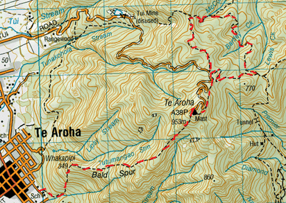
Head to Te Aroha Domain. We approach from Boundary St (as there’s plenty of parking and it’s close by) and walk towards Te Aroha Domain passing by the Spa and then the Hot Pool until we see a sign on the left for Bald Spur. This track starts off at an easy gradient and on a gravel track. We find the tracks here vary a bit from what’s on the Topo maps. We pretty much follow out gut and keep to the and head right on each occasion past 2 unmarked junctions. There is also a 3rd unmarked junction where I guess the old track went to the right which is not gravel, this time we keep to the main gravel path veering left. After about 10 minutes we reach a signposted junction (still not on the Topo map). Lower Domain Walk to the left and Upper Domain Walk to the right. There is no mention of Bald Spur as per the map, but we know we want to go up, so we head right. The track slopes upwards on an easy going gradient zig zagging. We soon pass some pretty massive Pine Trees and it’s not long after those before the gravel track gives way to earth and tree roots and the real tramping tramp begins. We pass a steep valley with a slight trickle of water going down and being home to lots of purple and green Parataniwha and there’s a small bridge over it where you can admire these cool plants growing up and also down the valley. After about 40 minutes we reach a viewing platform over Te Aroha, farmland and marsh below. This point is signposted as Whakapipi. From here the track headed steadily upwards, still zig-zagging. There are also a few tracks straight up in between the zig zags, and some of them a tad steep, but made an enjoyable change to the steady gradient. After the zig-zags, the gradient flattens off a bit and it’s not long before we reach a junction of signposted Horsemans Track to the left (again, this is not on the Topo map). We continue past and from here the track gets a tad steeper. There are a few log stairs and also a few rocky parts to climb too. The higher we climbed, the more moss we saw. There was also plenty of hanging moss which looks cool when it caught a sunbeam. Fairly close to the top there’s a flattish part of the track where all the trees were covered in moss (hanging and also in clumps) giving the place a real fairytale vibe. After about 2 hours we reached the summit where we find a building at the bottom of a TV Antenna shaped kinda like the Eiffel Tower. We walk around the building and pass the junction to the Dog Kennel Flat Track on the right. Behind the building there is a mound/small hill with the Trig on it that we climb up. There’s a great view up here of the Kaimai ranges and miles and miles the surrounding country side and also out to the East Coast. There are still a few clouds about so not all of the view is revealed. This was the perfect spot for a cuppa and some golden crunch cookies. Rested and refuelled we head back to the junction of the Dog Kennel Flat Track. This slopes downwards, then we head down some more log stairs then come out on a rocky exposed side of the mountain, down some more stairs and onto a wooden walkway. There is a great view here looking south over the contours of the Kaimais. We then head back into the bush and are surrounded with more cool mossy trees again and the track slopes downwards at an easy gradient. After close to half an hour we reach a flat gravel area to the left of the track, which is also at the side of the gravel Tui Road where various building materials are being temporarily kept for the maintenance work. We guess this is Dog Kennel Flat, but there is no signage that actually states this. There is one bit of signage though, there is a plastic container lid attached to the tree and written in marker pen, “Tui Saddle” and an arrow pointing left and also “Waitawheta” and an arrow pointing right. We can see there is a track on the other side of the gravel flat where the Tui Saddle track continues. We head to the right which is continuing on the track we were on. Underfoot the track becomes sawdust on some type fibre matting which works pretty well in keeping a natural vibe. Lucky for us, there is still a wee bit of mud about, but not as much as we’d like. After a few minutes we reach a T junction and there is another discreet handmade sign attached to a tree made of an offcut of wood with marker pen. “Tui Saddle” and an arrow to the left pointing out a Link track to Tui Saddle Track and “Mangakino” and an arrow pointing right. We head right, down an easy sloping gradient. After about 15 minutes or so we reach a signposted junction with a map attached. The path on the right leads to Waitawheta Hut and also to Waiorongomai, and to our left, the track leads to Mangakino Shelter. We head left. The track is fairly flattish, just undulating slightly where the track winds its way around the side of the mountain. After about 20 minutes we reach another junction which is unmarked going left and right. As we intend of doing a loop track, we keep left. Amongst the tranquil birdsong we also hear the trickle of the odd stream and we cross a couple of small streams too. One part of the track came out on an exposed steep rocky part of the mountain with a narrow ledge for the track. It was quite a drop down below and there was also a pretty good view out to the surrounding ranges. As the sun was also beaming down, we thought this was a great spot for lunch. Here we tucked into our Sticky Teriyaki Sesame Sarnies washed down by nice hot cuppa. Refuelled we carried on. Close to half an hour or so we reached another of these rocky exposed sides of the mountain, which had a tranquil wee waterfall on it (this too would make a great spot for lunch as well) and looked out the opposite side of the valley. Once past the waterfall on the opposite side of valley we also get a picturesque view of the trickling waterfall that we passed. After about an hour or so since our last junction we reach the next one. This junction has a signpost with a map. To the right is the Mangakino Track and to the left leads to Tui Mine and Tui Saddle Track. We continue on our loop and head left. From here the track gently slopes upwards. After 15 minutes or so we reach and also pass the closed off junction to the Tui Mine with signage advising closure due to maintenance and that it will be reopened in July 2013. We follow the remaining open track onwards and still slightly upwards still following the orange markers and now also following a plastic water pipe (which we hope is only temporary). After a while, we then arrive at a crossroads junction. To the left is the Tui Saddle Link Track, to the right is the gravel, Tui Road and straight ahead leads to Dog Kennel Flat. We continue straight ahead and up over a small rise and about 2 or 3 minutes later we arrive back at Dog Kennel Flat. This small loop took close to 2 ½ hours. From here we back track up Dog Kennel Flat Track, back to Te Aroha Summit. Half an hour later we’re back at the top and we have a water stop and admire the view again. Some of the cloud has disbursed and can now see Tauranga and the surrounding islands to the east and we can make out Kariori and Pirongia on the other side too. From here we back track down Bald Spur track, going down we realise that some parts are pretty steep and we really have to concentrate on our footing. About 2 hours later we’re back at the bottom. Total tramp time 7 ½ hours. |
Level of DifficultyModerate
Time7.5 Hours (Winter 2012)
|
|
