Conical Peak Walkway & back (Matakana)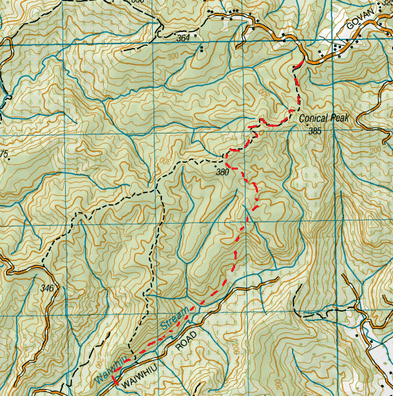
Head to Conical Peak Rd Car Park, off Govan Wilson Rd. You will see signage here to confirm you’re at the right place.
We pass though a gate (pedestrian access only) and follow a gravel road. On the right is private residence and we pass a couple of goats and a bit of a car graveyard. On the left we get a couple of view points looking out over Matakana and beyond out to sea. After about 10 minutes the road forks. Straight ahead the gravel continues to a sort of turning area and to the right is a clay 4WD track. There is signage that clearly points right, so we follow. The bush closes in a bit more and as it’s a bit of a rainy day, the hard orangey clay underfoot is a tad slippery with plenty of puddles. On this bit of track there is a gradual gentle upwards gradient and an occasional view as well. After about another 20 minutes we reach another junction. The 4WD track continues straight ahead and the signage clearly points left. We follow left and are now on a proper bush track where the bush closes in even more – this is more like it. From here the track deviates from the Topo map, but at least we can compare the streams on the map against the DoC printout (from their website) to get an idea of where we are. There’s also plenty of mud for us to enjoy, as well as a fair amount of tree roots under foot. This track is pretty easy going and starts off fairly flattish with the odd view on the left. After a while it starts to slope down gradually at first. We also notice that there are a few of Rimu about, leaving a carpet of needles about in parts. About 1 ¼ hours from starting out the track gradient descends fairly steeply down the Waiwhiu valley. At this part we find a large fallen tree inviting us to sit down and have a cuppa along with some golden crunch cookies. From there it was about just under half an hour until we were at the bottom of the hill where the track meets a small stream. There is also a junction. There is an unmarked path to the left. The signage clearly shows the track continues straight ahead across the steam. This is an easy and shallow crossing, so the shoes remain dry. After a few minutes the track then reaches the Waiwhiu Stream and heads right. The track then runs alongside the stream and we cross over quite a few small creeks feeding into the stream. There’s some pretty cool moss down here too. After close to half an hour the track heads across the steam where it is shallow and runs over rock. This crossing is also very picturesque. On the other side we head up the bank a few metres and then this track ends at a gravel road 2 ¼ hours from starting out. From here we turn around and back track the way we came. The weather cleared with plenty of sunbeams and gave the track a different perspective all together. Once at the top of the hill again we found a great spot with views looking out to Tii Point where we enjoyed a Morroccan Sarnie. We continued back tracking enjoying more views, as the clouds had lifted. We made it back to the car park 4 ½ hours from starting out. |
Level of DifficultyEasy
Time2.25 hours - one way (Spring 2012)
4.5 Hours - return (Spring 2012) Additional NotesRoute deviates from Topo Map
|
|
