Kuataika Stream Loop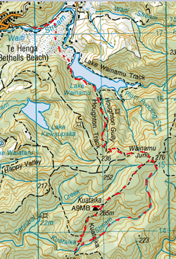
Head to the first Carpark at Bethell’s Beach, on the left just after the bridge over
Waiti Stream. Pass through the gate where you’ll see the sign for the Lake Wainamu Track. This track follows alongside the meandering stream on your left. The stream is shallow so you also have the option of walking through as well. After a while the sand dunes rise up on your right (there are some great patterns on the side of these dunes too), we leave the Lake Wainamu Track & veer diagonally right, up & across the sand dunes. There are plenty of footprints in the sand guiding the way. The vast space of these dunes gives off a unique vibe with the beautiful surrounding hills & farmland beyond. Starting out in the early morning is very peaceful with no one else about, just the natural sounds of the earth & the brilliant sparking sand all around. Soon enough we reach the top of the dunes & Lake Wainamu reveals itself, and we continue down. After about 20 minutes from starting out we reach the tranquil lake edge, with the early morning calm the lake is as smooth as glass. We follow the Lake side continuing right. You will then reach a gate where there is an established track. This continues lakeside through long grass & Kanukas & Nikau, up & down a few stairs & past some Pohutukawas. There are also a couple of small bridges Just over 15 minutes or so we reach the grassy clearing & T junction where the Lake Wainamu Track continues straight ahead & the Houghton Track is on the right. We head right. The Houghton track starts off upwards at a reasonable gradient at first, then gets fairly steeper. It does ease after up in parts, but is mostly just up. The canopy ahead is fairly dense giving the track a vibrant green hue and you can also hear & see Wood pigeon about too. After about 25 minutes or so, the Houghton Track veers to the left at a kind of right angle, then the gradient eases up a bit & after a while follows fenceline& then crosses over where the fence was. After about 45 minutes we reach the end of this track at the Wainamu Junction. The Kuataika is to the right, Smyth Ridge Track straight ahead & the Wainamu Bush Track is on the left. We head right on the Kuataika Track. This is a fairly wide (easily enough for a quad bike), exposed undulating orangey brown clay track. We pass a locked gate on our right (where there is a track leading towards the west coast) and continue straight on for close to 20 minutes. Not long after the track goes around a locked gate with wide concrete posts (why the lock wasn’t cut instead of clearing the bush around it, is a mystery), is a track on the right. This heads upwards over rocks, though a bit of manuka & gorse for a couple of minutes and leads to the Kuataika Trig Lookout. The views from here are spectacular looking out over the surrounding hills & valleys of the Waitaks as well as the coast beyond. This was the perfect spot for morning tea, where we stopped and soaked in the view & enjoyed the quiet of the world except for the harmony of birdsong. We then made our way back to the Kuataika Track an headed right & downwards. Minutes later we pass an unmarked track on our right (which heads towards Cannibal Creek). After close to 15 minutes, we reach the Kuataika Stream which flows across the Kuataika Track (which continues straight ahead). We now head left on the Kuataika Stream and make our way upstream. It’s quite a narrow stream with a tranquil flow and there is a thick canopy overhead. The banks on either side are covered in plenty of moss too. The stream is fairly shallow & we find ourselves wading in parts as well as walking to the side. The stream bank frequently changes, with one side getting steep and then the other, leading to countless stream crossings. As you would imagine there’s plenty of mozzies about, and often we get a face full of spiderweb too. There’s also plenty of fallen logs to climb under & over as well as making our way though epiphytes & debris. There are plenty of tranquil spots, actually just about everywhere you look. We find a nice wee bend in the stream where the bush feels a tad more spacious, where stop for Sweetcorn Mayo Sarnie & a nice cuppa. After about 1 ¾ hours on the stream, besides a small pool it was pretty easy going. From here through we encounter our first of a series of small waterfalls in which we have to scramble up rocks with the assistance of trusty epiphytes. After the water falls we find the stream narrows considerably after a bit of a swamp. This steam also splits off a couple of times, but we continue up in the direction of where there is more water flow. The surrounding epiphytes get pretty dense in places & we are contained to wading through the stream as the banks can be a tad impassable. We find one tricky part where the going is slow through a tangle of supplejack whilst wading our way upwards. There are also parts where the growth in the stream is too dense & we detour a fair bit away from the stream and then return back to the stream where the growth thins out again. There are also a couple of parts where the stream disappears underground, but you can still easily make out the stream bed. After about 3 hours on the stream, it completely disappears and we follow the stream bed, until that too disappears and then we make out way in a straight line veering to the right. Within about 10 minutes from the last of the stream bed we come out exactly at the Wainamu Junction. From here we back track all the way back down to the lake where we stop for a beautiful, well needed refreshing swim. We then continue back over the dunes the way we came and arrive back at the car about 6 ½ hours from starting out. |
Level of DifficultyModerate
Time6.5 Hours (Spring 2013)
|
|
