Wainamu - Smyth - Upper & Lower Kauri Track Loop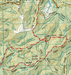
Head to the end of Long Road. The Long Road Track starts off past the gate and straight ahead on a gravel road heading upwards. On the left you’ll pass the junction of the Whatitiri Track.
The road has a few bends here & there & continues steadily upwards. If you pass here in Spring, there are plenty of wild purple Foxgloves on the roadside. There are some pretty goods views on either side the higher up you get. Towards the top it flattens out & on the right is a paddock (now cows today) .Then the bush finally closes in but this clay track is still wide enough for a 4 wheel drive and there’s lots of mud & puddles and the tramp begins. After about half an hour we come to the junction of the Lower Kauri Track on the left, we continue past. Close to 5 minutes later we come to the Junction of the Wainamu Track on the right. We head right. To our delight, the bush immediately closes in and the track is fairly narrow (especially compared to the Long Rd track). It starts off fairly flatish sloping slightly downwards before it really starts to descend a lot steeper and pretty slippery on the mud & clay under foot (even more so as it had been raining). We reach the bottom about half an hour from starting this track and come across the serene Wainamu Stream with dense canopy above, with mossy rocks on either side giving off a dim green hue. This was the perfect place for some warming tea & biccies. We then continue across the stream & head upwards again. The uphill climb is steady, but not hard out and soon flattens off again. The Bush is very dense with lots of young Kauri close together. If these were planted I don’t think there was too much forethought in the space that would be needed if these trees reach maturity. After about 1 ½ hours from starting , we reach the end of the track and approach the Wainamu junction. To the right was the Houghton Track, Opposite was the Kuataika Track and to the left is the Symth Ridge Track. We headed left on the Symth Ridge which was orangey brown clay, with plenty of mud & puddles and quite wide, very similar to the Long Road Tk. This started off fairly flat but soon heads uphill steadily. The smooth Orangey brown clay was quite slippery as there had been showers on & off that morning and our sticks really played their part keeping us steady (& upright). After another 40 minutes or so we reached the Smyth Junction where the Sisam Track is on the right. We found this junction a tad ambiguous as we headed straight ahead in search of the Upper Kauri Track. After a couple of minutes we pass another junction on the right with no signage except for a Hillary Trail marker. We continue straight on for another minute & find another junction to the left to the Long Road Track. We are still not 100% what track is straight ahead, but there is a sign saying that straight ahead leads to Long Rd & takes 55 minutes. Still no sign of Upper Kauri. After checking the map we deduct that straight ahead & right are both the Long Road Track. We head right. After a minute or so we see the track (on right) where the Hillary trail links on to this one. We continue straight ahead for another minute or two and find the junction we were looking for. To the Left is the start of the Upper Kauri Track and straight on is the Long Road Track. We head right. This track is gravel, but is still fairly narrow with the bush nice & close on each side. There are plenty of interesting trees and moss. This track slopes gently downwards, about twenty minutes into it you see a few mature Kauris. After About 45 minutes from starting this track we come the part of the track which changes from gravel to boardwalk and there are some pretty impressive mature Kauris. Also is the junction on the left for the Lower Kauri Track and the Upper Kauri Track continues straight ahead. We turn left and back on to glorious mud again. The bush closes in again and there are a few younger kauri here amongst plenty of other stuff. The track heads downwards and past a bit more of wooden stairs that are damn slippery. I really don’t appreciate walking on mademade stuff in the bush. Natural tracks, ie: roots & mud, streams, trees & moss n stuff – that’s what it’s all about. We cross a small stream then head up a bit and we are greeted by a flat part of the bush with plenty of space under the canopy track side to stop, spread out & satisfy our rumbling tummies with sarnies and a hot cuppa. The rain knows it’s lunchtime again, but the Pungas keep us dry enough. Afterwards we continue flat for a bit, then track slopes down again and we cross another small stream. From here the track starts the ascent and there is plenty of mud & puddles that are keen to keep hold of our boots. We continue steady upwards and it’s not long before we hear the Lorikeets in the Rewarewas and Kauri Trees. It’s slightly steeper here, but not for too long. There are some great big Kauri at the top and then the track flattens out to more muddy puddles. After about 45 minutes we come back to the junction of the Long road Track going left & right. We head left and back track the way we came down the hill and to the car. Total Loop Time about 5 hours. |
Level of DifficultyEasy
Total Track Time5 hours - anticlockwise (Spring 2011)
4.25 hours - anticlockwise (Autumn 2013) 4.25 hours - clockwise (Winter 2013) |
|
